
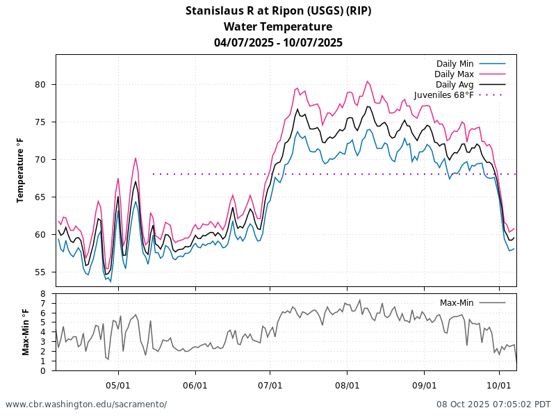
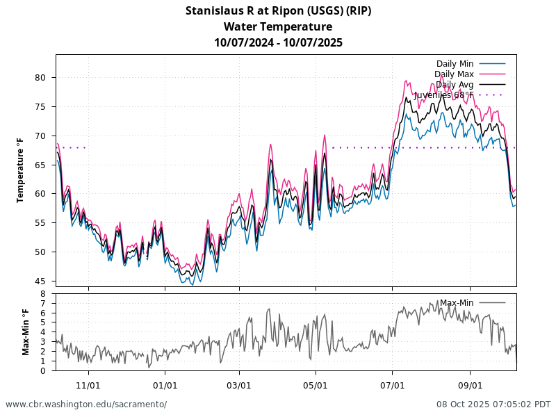
Stanislaus Temperature and Flow
Current River Conditions
Stanislaus Watershed Select River Conditions for 2026-03-21
| Stanislaus | Tuolumne | Merced | San Joaquin | |||||||||||||
|---|---|---|---|---|---|---|---|---|---|---|---|---|---|---|---|---|
| Location | GDW | OBB | RIP | KOT | LGN | TRW | MOD | TRT | MBH | CRS | MST | NEW | MRB | VNS | MSD | OH1 |
| Flow (CFS) | 203 |
224 |
186 |
255 |
1233 |
1367 |
1672 |
1754 |
304 |
110 |
240 |
1217 |
2503 |
3575 |
3170 |
2367 |
Click on the icon to view current 60 days plot for location and river conditions.
| Stanislaus | Tuolumne | Merced | San Joaquin | |||||
|---|---|---|---|---|---|---|---|---|
| Location | OBB | RIP | RPN | MOD | CRS | VNS | MSD | OH1 |
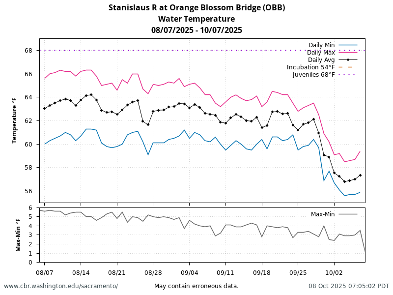
| Water Temperature (°F) | 59.7 |
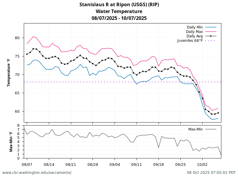
68.2 |
69.4 |
57.8 |
66.4 |
65.0 |
65.2 |
65.4 |
Click on the icon to view current 60 days plot for location and river conditions.
| Stanislaus | Tuolumne | Merced | San Joaquin | |
|---|---|---|---|---|
| Location | SNS | TLG | MRC | SBF |
| Full Natural Flow (CFS) | 3026 a |
5484 a |
3626 a |
7572 a |
Note: a. Data is not available for 2026-03-21. Most recent data up to 5 days prior is reported.
Click on the icon to view current 60 days plot for location and river conditions.
| Stanislaus | Tuolumne | Merced | San Joaquin | |
|---|---|---|---|---|
| Location | NML | DNP | EXC | MIL |
| Reservoir Storage (TAF) | 1879 |
1711 |
754 |
409 |
| Res Above Top of Conserv Stor (TAF) | -95 |
24 a |
53 a |
-84 a |
| Reservoir Inflow (CFS) | 4304 |
3324 a |
3607 a |
3085 a |
| Reservoir Outflow (CFS) | 792 |
4471 a |
1279 a |
1589 a |
Note: a. Data is not available for 2026-03-21. Most recent data up to 5 days prior is reported.
Click on the icon to view current 60 days plot for location and river conditions.
| Stanislaus | San Joaquin | ||
|---|---|---|---|
| Location | RPN | MSD | OH1 |
| Dissolved Oxygen (mg/L) | 8.1 |
8.6 |
8.0 |
Click on the icon to view current 60 days plot for location and river conditions.
Data retrieved from CDEC; Current River Conditions tables generated by SacPAS.
Juvenile Sampling

Juvenile Sampling Summary
| Date Range | Data Item | Caswell Memorial State Park RSTs | Mossdale Trawls | Antioch Dunes SJ001S | Eddo's SJ005N | Medford Island SJ026S | Lost Isle SJ032S | Dad's Point SJ041N | Dos Reis SJ051E | Mossdale SJ056E | Weatherbee SJ058W | Big Beach SJ063W | Durham Site SJ068W | Sturgeon Bend SJ074W | Two Rivers RV Park SJ075E | Route 132 SJ077E | N. of Tuol. R. SJ083W |
|---|---|---|---|---|---|---|---|---|---|---|---|---|---|---|---|---|---|
| Date Range | Data Item | Caswell Memorial State Park RSTs | Mossdale Trawls | Antioch Dunes SJ001S | Eddo's SJ005N | Medford Island SJ026S | Lost Isle SJ032S | Dad's Point SJ041N | Dos Reis SJ051E | Mossdale SJ056E | Weatherbee SJ058W | Big Beach SJ063W | Durham Site SJ068W | Sturgeon Bend SJ074W | Two Rivers RV Park SJ075E | Route 132 SJ077E | N. of Tuol. R. SJ083W |
| 03/08/2026-03/21/2026 | Min Sample Date | 2026-03-09 | 2026-03-09 | 2026-03-12 | 2026-03-10 | 2026-03-20 | |||||||||||
| 03/08/2026-03/21/2026 | Max Sample Date | 2026-03-20 | 2026-03-19 | 2026-03-12 | 2026-03-10 | 2026-03-20 | |||||||||||
| 03/08/2026-03/21/2026 | Days with Sampling | 0 | 0 | 0 | 0 | 0 | 0 | 0 | 0 | 0 | 0 | 0 | 0 | 0 | 0 | 0 | 0 |
| 03/08/2026-03/21/2026 | Fall Chinook | 2 | 0 | 0 | 0 | 0 | |||||||||||
| 03/08/2026-03/21/2026 | Spring Chinook | 0 | 0 | 0 | 0 | 0 | |||||||||||
| 03/08/2026-03/21/2026 | Winter Chinook | 1 | 0 | 0 | 0 | 0 | |||||||||||
| 03/08/2026-03/21/2026 | LateFall Chinook | 0 | 0 | 0 | 0 | 0 | |||||||||||
| 03/08/2026-03/21/2026 | Chinook (ad-clip) | 0 | 0 | 0 | 0 | 0 | |||||||||||
| 03/08/2026-03/21/2026 | Steelhead (natural) | 0 | 0 | 0 | 0 | 0 | |||||||||||
| 03/08/2026-03/21/2026 | Steelhead (ad-clip) | 0 | 0 | 0 | 0 | 0 | |||||||||||
| 03/08/2026-03/21/2026 | Avg Flow (cfs) | 202.9 | 4688.4 | ||||||||||||||
| 03/08/2026-03/21/2026 | Avg Water Temp (F) | 32.0 | 60.0 | 60.2 | 60.1 | 57.0 | 61.9 | ||||||||||
| 03/08/2026-03/21/2026 | Avg Turbidity (NTU) | ||||||||||||||||
| 02/22/2026-03/07/2026 | Min Sample Date | 2026-02-23 | 2026-02-24 | 2026-02-27 | 2026-03-04 | 2026-02-27 | 2026-03-04 | 2026-02-27 | |||||||||
| 02/22/2026-03/07/2026 | Max Sample Date | 2026-03-05 | 2026-02-24 | 2026-02-27 | 2026-03-04 | 2026-02-27 | 2026-03-04 | 2026-03-04 | |||||||||
| 02/22/2026-03/07/2026 | Days with Sampling | 0 | 0 | 0 | 0 | 0 | 0 | 0 | 0 | 0 | 0 | 0 | 0 | 0 | 0 | 0 | 0 |
| 02/22/2026-03/07/2026 | Fall Chinook | 6 | 1 | 0 | 0 | 0 | 1 | 0 | |||||||||
| 02/22/2026-03/07/2026 | Spring Chinook | 0 | 0 | 0 | 0 | 0 | 0 | 0 | |||||||||
| 02/22/2026-03/07/2026 | Winter Chinook | 1 | 0 | 0 | 0 | 0 | 0 | 0 | |||||||||
| 02/22/2026-03/07/2026 | LateFall Chinook | 0 | 0 | 0 | 0 | 0 | 0 | 0 | |||||||||
| 02/22/2026-03/07/2026 | Chinook (ad-clip) | 0 | 0 | 0 | 0 | 0 | 0 | 0 | |||||||||
| 02/22/2026-03/07/2026 | Steelhead (natural) | 0 | 0 | 0 | 0 | 0 | 0 | 0 | |||||||||
| 02/22/2026-03/07/2026 | Steelhead (ad-clip) | 0 | 0 | 0 | 0 | 0 | 0 | 0 | |||||||||
| 02/22/2026-03/07/2026 | Avg Flow (cfs) | 358.8 | 7163.5 | ||||||||||||||
| 02/22/2026-03/07/2026 | Avg Water Temp (F) | 32.0 | 56.0 | 52.5 | 58.8 | 59.0 | 58.1 | 57.4 | 57.2 | ||||||||
| 02/22/2026-03/07/2026 | Avg Turbidity (NTU) | ||||||||||||||||
| source of Avg Flow (cfs) | Ripon USGS (CDEC:RIP) | Vernalis (CDEC:VNS) | Vernalis (CDEC:VNS) | Vernalis (CDEC:VNS) | Vernalis (CDEC:VNS) | Vernalis (CDEC:VNS) | Vernalis (CDEC:VNS) | Vernalis (CDEC:VNS) | Vernalis (CDEC:VNS) | Vernalis (CDEC:VNS) | Vernalis (CDEC:VNS) | Vernalis (CDEC:VNS) | Vernalis (CDEC:VNS) | Vernalis (CDEC:VNS) | Vernalis (CDEC:VNS) | Vernalis (CDEC:VNS) | |
| source of Avg Water Temp (F) | Caswell RST | Vernalis (CDEC:VNS) | Antioch Dunes | Eddo's | Medford Island | Lost Isle | Dad's Point | Dos Reis | Mossdale | Weatherbee | Big Beach | Durham Site | Sturgeon Bend | Two Rivers RV Park | Route 132 | N. of Tuol. R. | |
| source of Avg Turbidity (NTU) | Caswell RSTs | Mossdale Trawls | Antioch Dunes | Eddo's | Medford Island | Lost Isle | Dad's Point | Dos Reis | Mossdale | Weatherbee | Big Beach | Durham Site | Sturgeon Bend | Two Rivers RV Park | Route 132 | N. of Tuol. R. |
- Caswell Memorial State Park RSTs: Preliminary data from PSMFC via CalFish and CDEC; subject to revision.
- Mossdale Trawls: Preliminary data from USFWS Lodi and CDEC; subject to revision.
- Antioch Dunes Beach Seine: Preliminary data from USFWS Lodi and CDEC; subject to revision.
- Eddo's Beach Seine: Preliminary data from USFWS Lodi and CDEC; subject to revision.
- Medford Island Beach Seine: Preliminary data from USFWS Lodi and CDEC; subject to revision.
- Lost Isle Beach Seine: Preliminary data from USFWS Lodi and CDEC; subject to revision.
- Dad's Point Beach Seine: Preliminary data from USFWS Lodi and CDEC; subject to revision.
- Dos Reis Beach Seine: Preliminary data from USFWS Lodi and CDEC; subject to revision.
- Mossdale Beach Seine: Preliminary data from USFWS Lodi and CDEC; subject to revision.
- Weatherbee Beach Seine: Preliminary data from USFWS Lodi and CDEC; subject to revision.
- Big Beach Beach Seine: Preliminary data from USFWS Lodi and CDEC; subject to revision.
- Durham Site Beach Seine: Preliminary data from USFWS Lodi and CDEC; subject to revision.
- Sturgeon Bend Beach Seine: Preliminary data from USFWS Lodi and CDEC; subject to revision.
- Two Rivers RV Park Beach Seine: Preliminary data from USFWS Lodi and CDEC; subject to revision.
- Route 132 Beach Seine: Preliminary data from USFWS Lodi and CDEC; subject to revision.
- N. of Tuol. R. Beach Seine: Preliminary data from USFWS Lodi and CDEC; subject to revision.
- Averages: calculated for all non-null data points within the 7 day reporting period.
Data retrieved from PSMFC via CalFish, CDEC, DatCall email distribution. Figure and Table generated by SacPAS.
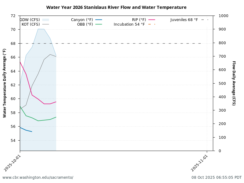
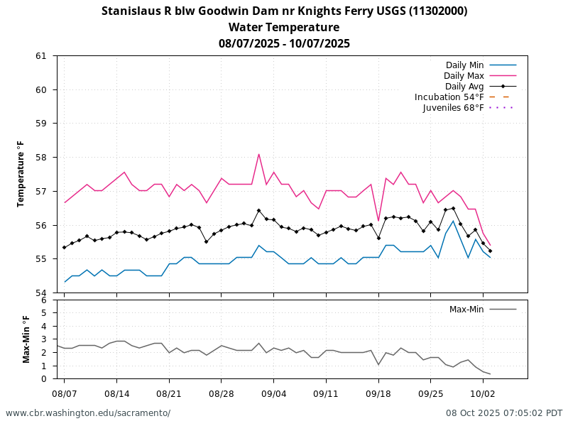
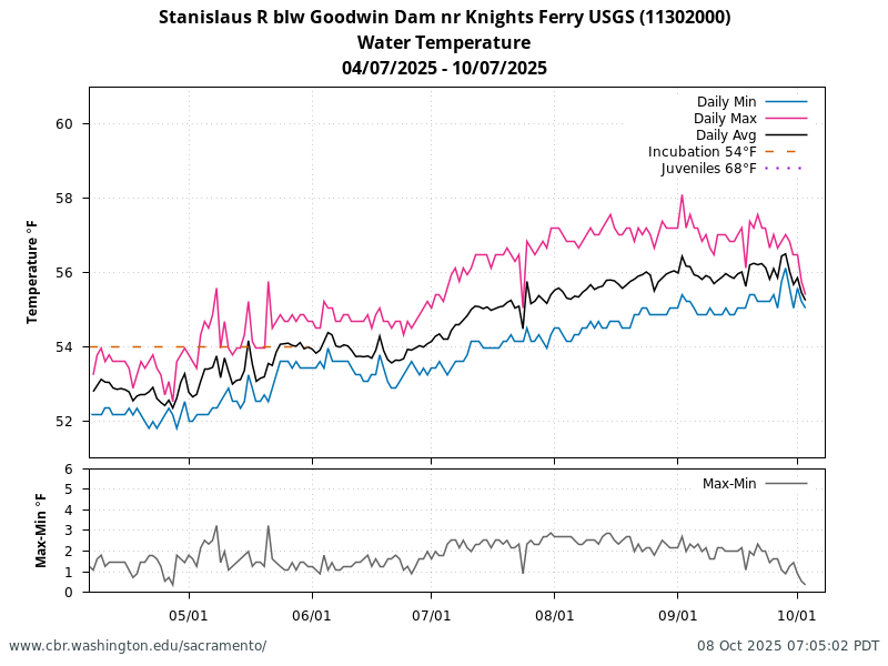
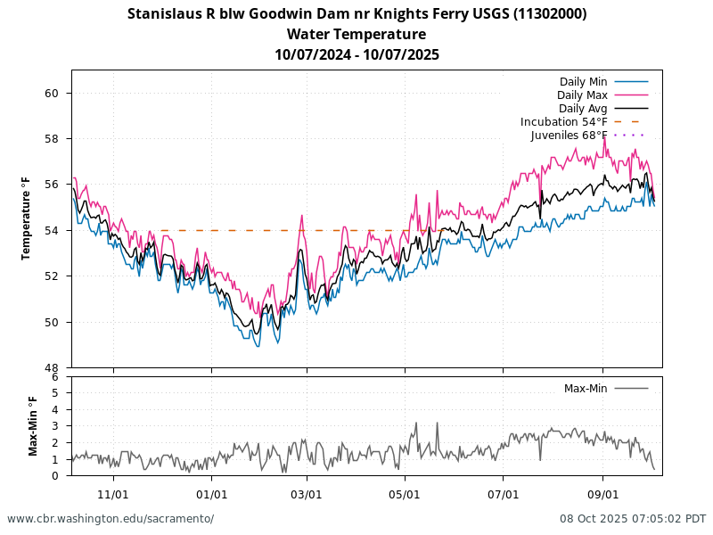
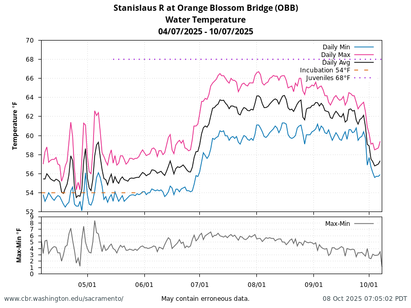
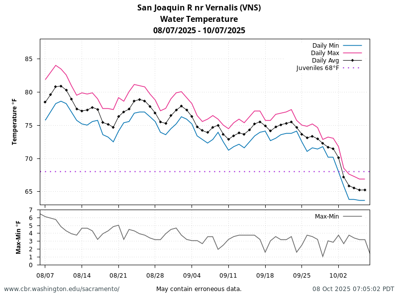
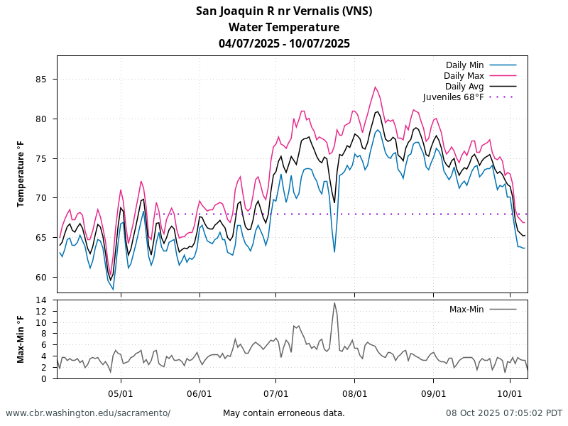
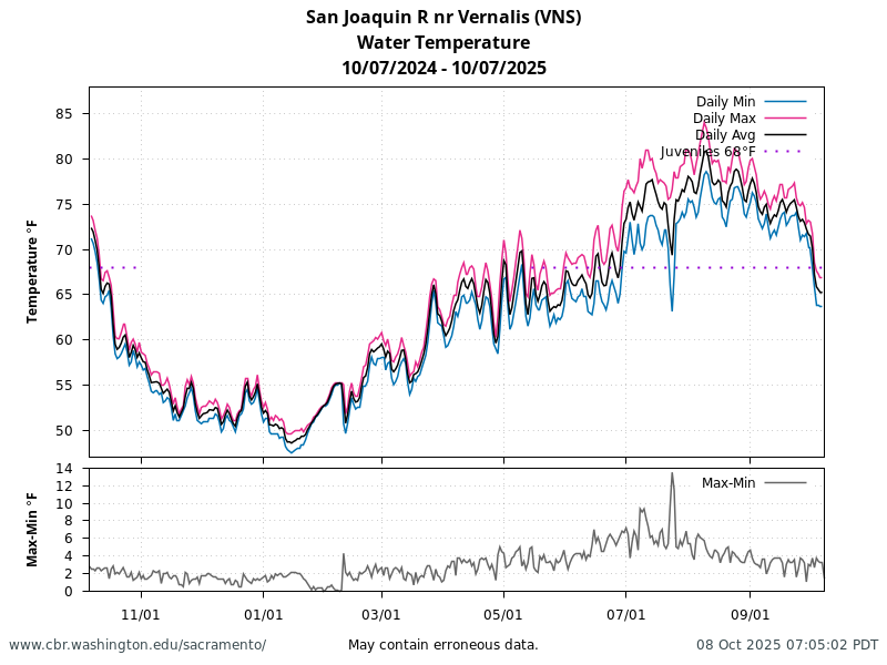
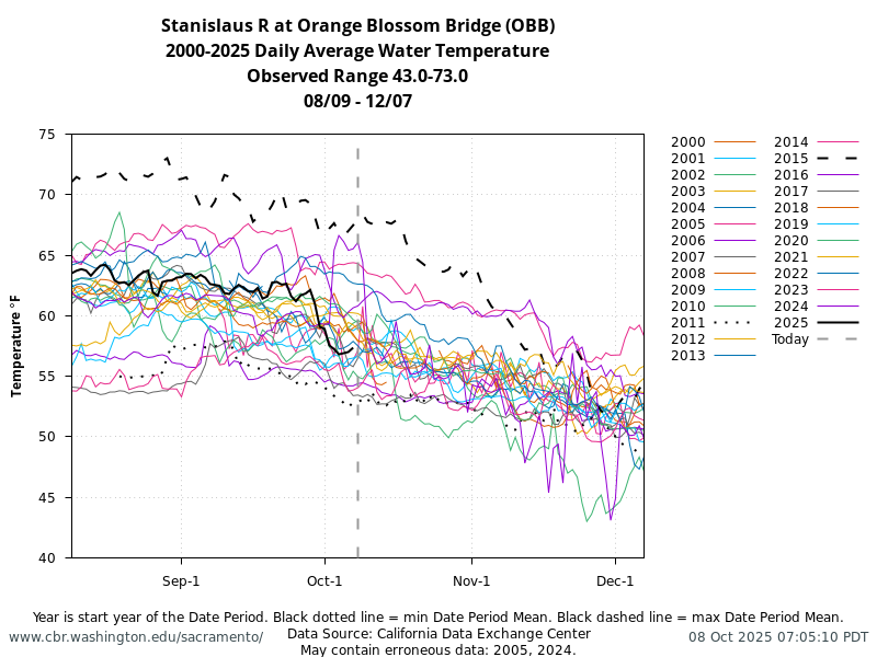
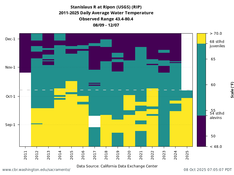
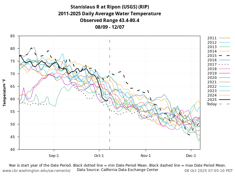
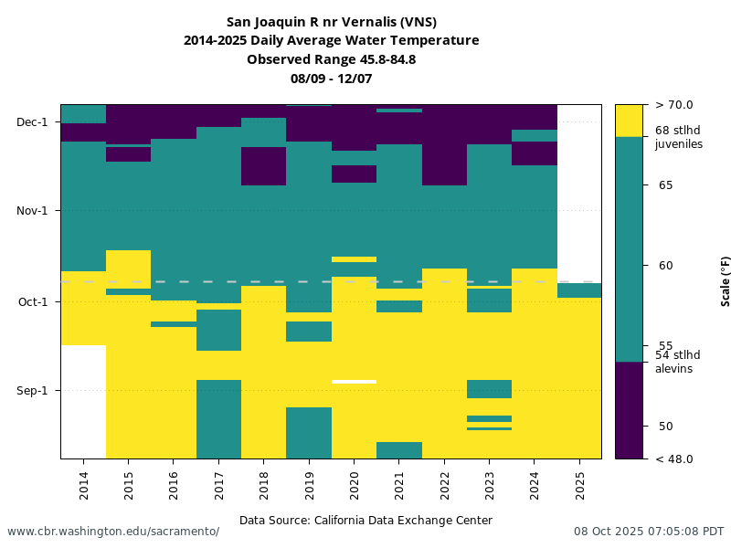
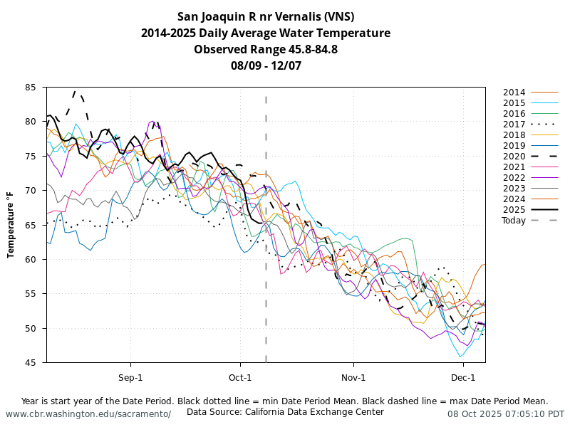
60-Day Water Temperature Daily Min, Max, Average Figures
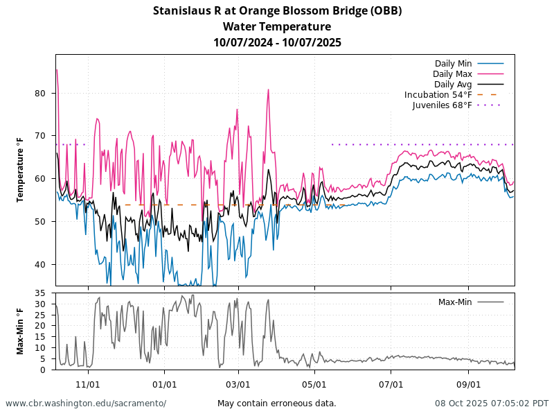
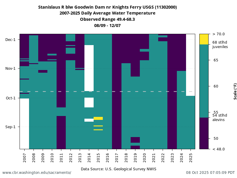
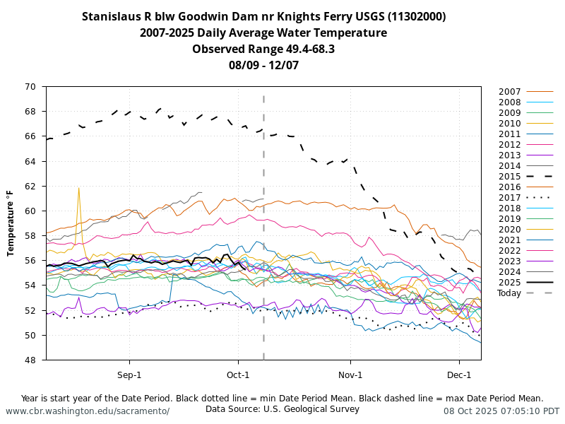
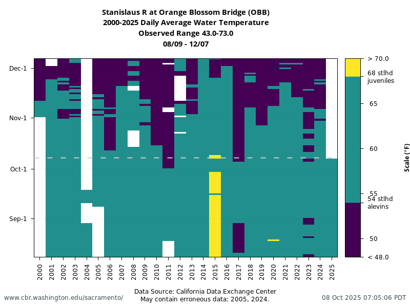
Historical & Current Water Temperature Figures
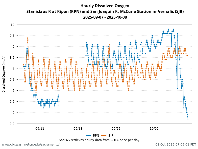
Hourly Dissolved Oxygen
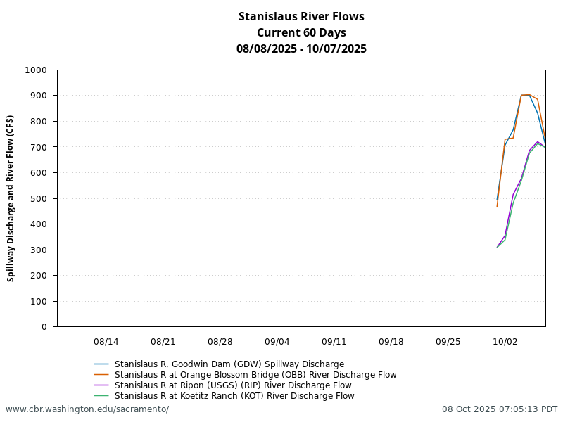
Stanislaus River Flows
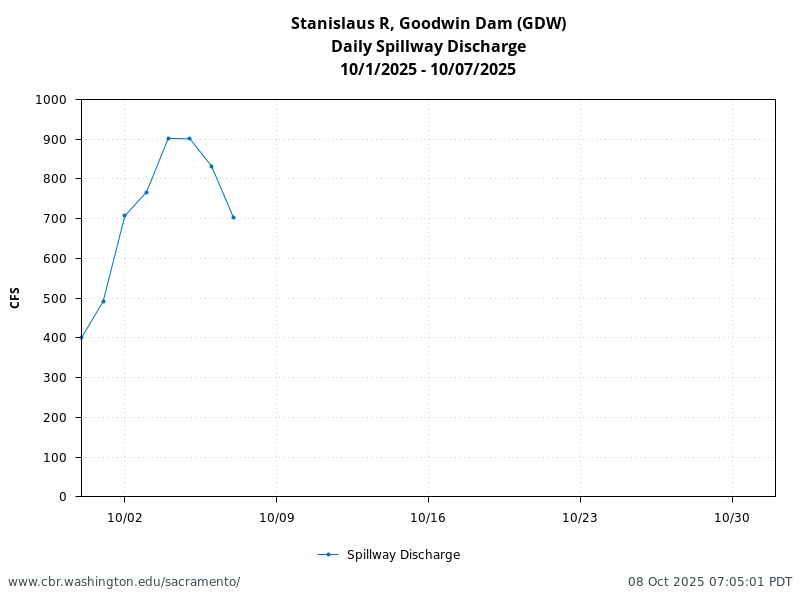
Goodwin Dam Spillway Discharge
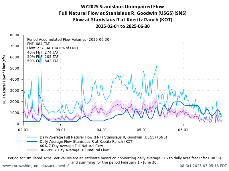
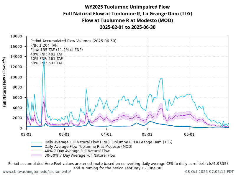
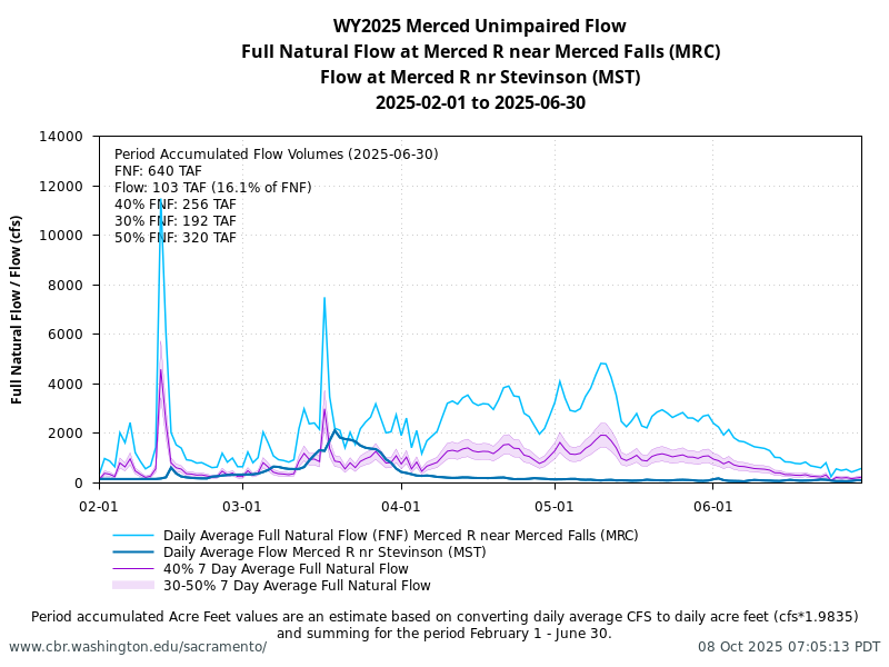
Unimpaired Flow
Unimpaired flow is monitored February through June at specific locations in the Stanislaus, Tuolumne, and Merced rivers.
Data Locations Map
Mossdale Trawls Juvenile Chinook Sampling Table
| Date | Species | Catch | Fork Length (mm) | Markcode | Lifestage |
|---|---|---|---|---|---|
| Date | Species | Catch | Fork Length (mm) | Markcode | Lifestage |
| 2026-01-05 | Chinook | 1 | 34 | None | parr |
| 2026-01-08 | Chinook | 1 | 34 | None | fry |
| 2026-01-08 | Chinook | 1 | 34 | None | fry |
| 2026-01-08 | Chinook | 1 | 34 | None | fry |
| 2026-01-08 | Chinook | 1 | 34 | None | fry |
| 2026-01-08 | Chinook | 1 | 35 | None | fry |
| 2026-01-08 | Chinook | 1 | 36 | None | fry |
| 2026-02-17 | Chinook | 1 | 47 | None | parr |
| 2026-02-18 | Chinook | 1 | 34 | None | fry |
| 2026-02-20 | Chinook | 1 | 33 | None | fry |
| 2026-02-20 | Chinook | 1 | 33 | None | fry |
| 2026-02-20 | Chinook | 1 | 35 | None | fry |
| 2026-02-20 | Chinook | 1 | 35 | None | fry |
| 2026-02-20 | Chinook | 1 | 36 | None | fry |
| 2026-02-20 | Chinook | 1 | 36 | None | fry |
| 2026-02-20 | Chinook | 1 | 38 | None | fry |
| 2026-02-20 | Chinook | 1 | 38 | None | fry |
| 2026-02-20 | Chinook | 1 | 41 | None | fry |
| 2026-02-23 | Chinook | 1 | 35 | None | fry |
| 2026-02-25 | Chinook | 1 | 34 | None | fry |
| 2026-02-25 | Chinook | 1 | 44 | None | parr |
| 2026-02-27 | Chinook | 1 | 45 | None | parr |
| 2026-03-02 | Chinook | 1 | 49 | None | parr |
| 2026-03-02 | Chinook | 1 | 52 | None | parr |
| 2026-03-04 | Chinook | 1 | 100 | None | silvery parr |
| 2026-03-09 | Chinook | 1 | 48 | None | parr |
| 2026-03-09 | Chinook | 1 | 63 | PkLC | parr |
| 2026-03-13 | Chinook | 1 | 78 | AdClipped | silvery parr |
| 2026-03-13 | Chinook | 1 | 82 | AdClipped | silvery parr |
| 2026-03-18 | Chinook | 1 | 49 | None | parr |
| 2026-03-18 | Chinook | 1 | 68 | AdClipped | silvery parr |
| 2026-03-18 | Chinook | 1 | 78 | AdClipped | silvery parr |
| 2026-03-18 | Chinook | 1 | 81 | AdClipped | silvery parr |
| 2026-03-18 | Chinook | 1 | 84 | AdClipped | silvery parr |
| 2026-03-18 | Chinook | 1 | 85 | AdClipped | silvery parr |
| 2026-03-18 | Chinook | 1 | 85 | AdClipped | silvery parr |
| 2026-03-18 | Chinook | 1 | 90 | AdClipped | silvery parr |
| 2026-03-18 | Chinook | 1 | 92 | AdClipped | silvery parr |
| 2026-03-18 | Chinook | 1 | 94 | None | smolt |
| 2026-03-20 | Chinook | 1 | 70 | AdClipped | silvery parr |
| 2026-03-20 | Chinook | 1 | 77 | AdClipped | silvery parr |
| 2026-03-20 | Chinook | 1 | 85 | AdClipped | silvery parr |
| 2026-03-20 | Chinook | 1 | 87 | AdClipped | silvery parr |
| 2026-03-20 | Chinook | 1 | 89 | AdClipped | silvery parr |
Preliminary data from USFWS Lodi; subject to revision. Table generated by SacPAS.
Data Notes
Content on this page is updated daily and includes the most up-to-date datasets contained in the SacPAS database.
SacPAS Related Queries and Tools:
- Juvenile Monitoring & Sampling data queries
- River Conditions data queries